


Zion Voting District, Wythe County, Virginia
About
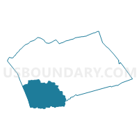
Outline

Summary
| Unique Area Identifier | 682711 |
| Name | Zion Voting District |
| County | Wythe County |
| State | Virginia |
| Area (square miles) | 70.64 |
| Land Area (square miles) | 70.47 |
| Water Area (square miles) | 0.17 |
| % of Land Area | 99.75 |
| % of Water Area | 0.25 |
| Latitude of the Internal Point | 36.81580600 |
| Longtitude of the Internal Point | -81.19422850 |
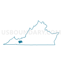
Maps

Graphs
Select a template below for downloading or customizing gragh for Zion Voting District, Wythe County, Virginia


Neighbors
Neighoring Voting District (by Name) Neighboring Voting District on the Map
- Comers Rock Voting District, Grayson County, VA
- Elk Creek Voting District, Grayson County, VA
- Evergreen Voting District, Wythe County, VA
- Fries Part 1 Voting District, Grayson County, VA
- Huddle Voting District, Wythe County, VA
- Providence Voting District, Grayson County, VA
- Rural Retreat Voting District, Wythe County, VA
- Sugar Grove Voting District, Smyth County, VA
Top 10 Neighboring County Subdivision (by Population) Neighboring County Subdivision on the Map
- Black Lick district, Wythe County, VA (4,964)
- Rye Valley district, Smyth County, VA (4,754)
- Speedwell district, Wythe County, VA (4,689)
- Providence district, Grayson County, VA (4,039)
- Elk Creek district, Grayson County, VA (4,003)
Top 10 Neighboring Unified School District (by Population) Neighboring Unified School District on the Map
- Smyth County Public Schools, VA (32,208)
- Wythe County Public Schools, VA (29,235)
- Grayson County Public Schools, VA (15,533)
Top 10 Neighboring State Legislative District Lower Chamber (by Population) Neighboring State Legislative District Lower Chamber on the Map
Top 10 Neighboring State Legislative District Upper Chamber (by Population) Neighboring State Legislative District Upper Chamber on the Map
Top 10 Neighboring 111th Congressional District (by Population) Neighboring 111th Congressional District on the Map
Top 10 Neighboring Census Tract (by Population) Neighboring Census Tract on the Map
- Census Tract 504.01, Wythe County, VA (4,010)
- Census Tract 503.02, Wythe County, VA (3,200)
- Census Tract 602.02, Grayson County, VA (3,158)
- Census Tract 601.01, Grayson County, VA (3,095)
- Census Tract 305, Smyth County, VA (2,799)
- Census Tract 304, Smyth County, VA (2,068)
Top 10 Neighboring 5-Digit ZIP Code Tabulation Area (by Population) Neighboring 5-Digit ZIP Code Tabulation Area on the Map
- 24382, VA (14,366)
- 24368, VA (4,953)
- 24375, VA (1,611)
- 24350, VA (1,261)
- 24326, VA (1,058)
- 24374, VA (787)
- 24323, VA (644)
- 24322, VA (174)